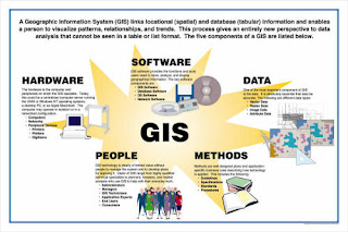
GIS is made up of a number of things. The first thing is Methods / Procedures. Methods and Procedures can be anything ranging from who needs the data you will provide to how the user will utilize the data you are providing. Secondly, you have to have a well thought out implementation plan. When you are putting together the implementation plan you might want to ask yourself three questions: have I documented my procedures, is all the hardware / software in place, and have I properly tested the proposed system. If you can answer those three questions you are probably on your way to a solid GIS plan. The third thing that a GIS is made up of is people. There are three types of people involved in a GIS. The first is the viewer (this could be the general public and / or anybody that will be utilizing your system). Second you will have the general users. Your users will be administrators and internal departments in your organization. The last set of people involved would be your GIS specialists. These are the people that make the GIS system work and function properly. The GIS specialists are managers, analyst, technicians, and field technicians. The next item you will have to deal with when looking at a GIS is hardware. Hardware is anything tangible needed to complete your overall objective. Examples of hardware would be a computer and server. Next you will need software. Software is what you will need to run on the hardware to make build and display your workspace. Without the proper software you are sunk. There are many softwares out there that are being used. the first few that come to mind are ESRI, Intergraph (Geomedia), and Google Earth. Lastly, you will need data to build out your GIS. You can gather this data with the help of your Field Technicians. Gathered data would be any attribute that was gathered with a field data device. An example of a field data device would be a GPS unit. You can also utilize documented data to incorporate into your GIS such as digital as-builts and land deeds.


